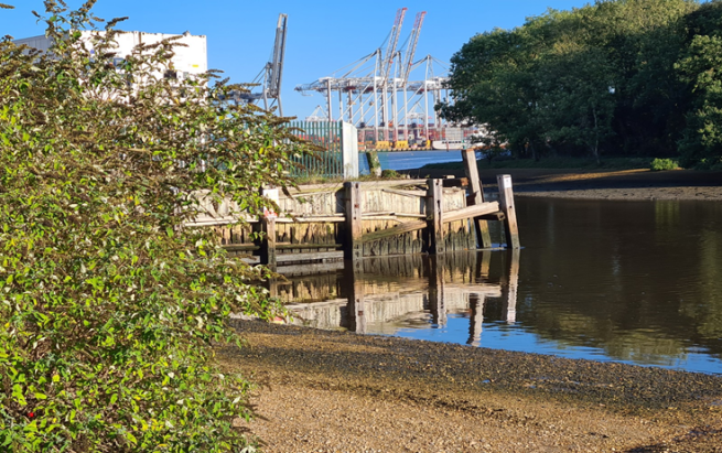
Eling Wharf
Back in October 2021, we reported on the worrying state of the sea walls at Eling Wharf. The walls of the wharf are showing distinct signs of possible collapse risking not only injury but also contamination and pollution of the surrounding water.
A letter has been sent to ABP regarding the condition of the wall copied to the Rt Hon Dr Julian Lewis MP, Solent Forum, NFDC, Totton and Eling Town Council and Cllr David Harrison. An initial response has been received from Rt Hon Dr Julian Lewis MP.
Beachbuoy and sewage discharges
Beachbuoy is Southern Water’s online information display for recent and ongoing storm overflow discharges. We first covered this application, explaining how to access and interpret it in a post last June. Since that time, the SPS Pollution Group have been keeping a close eye on the Beachbuoy data released by Southern Water, while at the same time performing detailed analysis of the spill data released by the Environment Agency and similar analysis performed by the Rivers Trust.
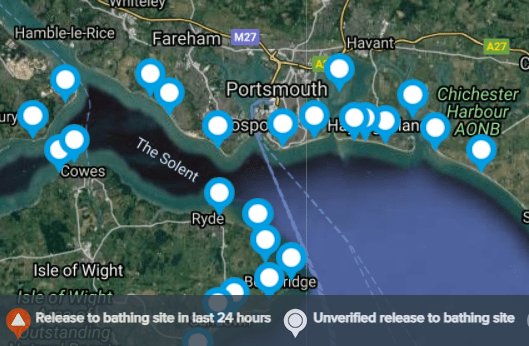
The SPS group responded to Southern Water’s recent Beachbuoy survey following some of the changes Southern Water has already made.
Our feedback is summarised below:
| Solent Protection Society believes that the scope and coverage of the Beachbuoy data provided by Southern Water , which already covers Langstone and Chichester harbours, should be expanded to include all other Solent harbours and estuaries, including Southampton Water, Portsmouth Harbour and Western Solent. We would like to see location pins – monitoring points – included at the following sites: 1) Off the mouth of the Test and Itchen rivers at the top of Southampton Water 2) Off the mouth of Ashlett Creek and the Hamble River in the centre of Southampton Water 3) Off the mouth of the Lymington River in the Western Solent 4) Off the mouth of the Beaulieu river in the Western Solent 5) In the centre of Portsmouth Harbour These pins should monitor CSO outfalls from within the rivers and on the adjoining foreshores on all sides of the Solent. The new icons introduced in a recent Beachbuoy update need further revision. Our feedback to Southern Water suggests the following improvements: 1) Icons should enlarge to at least twice the size as the user zooms in to the map. They currently become very hard to see once other features on the map get bigger. 2) It is not acceptable for the public to have to wait until a spill is reviewed or verified before a warning is issued by the system. 3) The white icon should have red or some other warning colour as it can sometimes take Southern Water several days to ‘verify’ a spill. 4) We are not satisfied all icons are correctly located or addressed. We would welcome the ‘spill volume’ information as promised and also believe that water quality, if included by 2023, would need to be linked to Environment Agency monitoring, including water quality tests after rainfall. |
These comments have been forwarded directly to the Southern Water Bathing Water Manager, with whom we have a meeting in the near future.
Recent Monitoring of Combined Storm Overflows
Spills that have been reported in BeachBuoy have been monitored for the last three months. November results have shown that if there is no rain Southern Water’s treatment works can generally cope. The December results show a very different story with discharges in the Solent area of 1,000 hours.
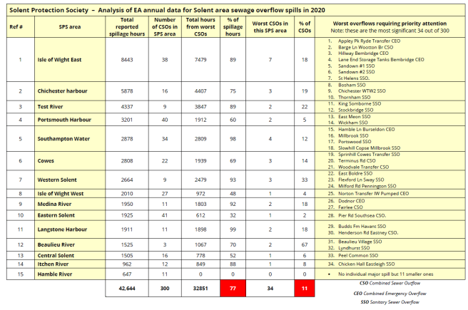
SPS Analysis of 2020 full year data, issued by Environment Agency in 2021
Annual spill data for the full year 2020 is discussed in a separate post, here. In summary, our analysis shows that 77% of the spills recorded in 2020 came from just 34 of the 300 main locations around the Solent.