
The Bembridge and St Helens area has an interesting history. The Harbour has been known historically as Brading Haven. In Roman times, small trading ships were worked up the Eastern River Yar to the quay at Brading. The estuary was much larger and extended across the area which is now Brading Marshes, forming a much larger inlet or estuary. In early medieval times Bembridge village grew from a few dwellings on the point to become a collection of hamlets and Brading was an important port for the Island. The Bembridge peninsular was cut off from the main Island by water or a marshy area near Brading, at the top of the Haven, and was known as “Binbridge Isle”.
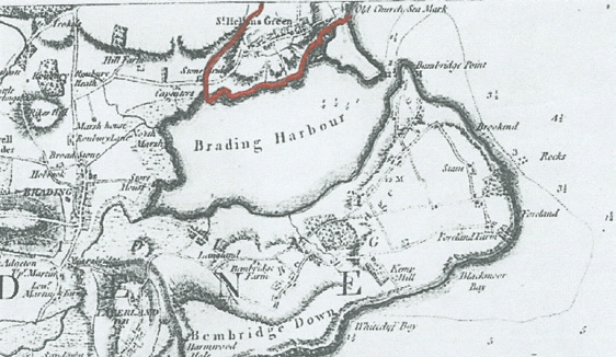
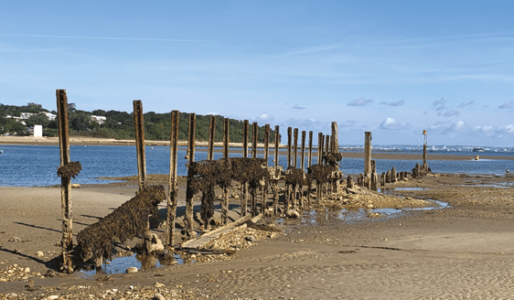
The topography of the harbour we know today is largely due to the draining of a major portion of the old Brading Haven for agriculture. The drained portion forms Brading Marshes, now a nature reserve. There are four documented attempts to drain the Haven, the most recent of which was completed in the 1870s and shaped the current harbour. The main embankment was eventually built for the railway and lies inland of the current embankment road. The result was disastrous for the future of the harbour; the smaller area has a reduced tidal prism (the amount of water flowing in and out on each tide) and most of the flow of water from the Eastern Yar River was blocked with sluice gates. The reduced tidal prism, combined with the sluice gates, limited the capacity of the tide to transport sediment through and out of the harbour estuary, causing the serious silting with which the Harbour Company and harbour users struggle today. Dredging is essential to keep the harbour open. Silting is further exacerbated by the north westerly longshore drift along the beach on the Bembridge side of the entrance some of the beach protection groynes are over 100 years old and have been allowed to fall into disrepair. Sand is carried by both wind and longshore drift along the beach in the direction of the harbour entrance. Currently there is an organised initiative to raise money to rebuild the groyne on Bembridge Point on the
south easterly side of the harbour entrance. Without a major seawall or strong groyne reaching from the harbour entrance out towards the St Helens Fort, total prevention of the longshore drift would be impossible, but the rebuilding of the main Bembridge Point groyne may well be successful in reducing the build-up of sand inside the harbour entrance. This is a large undertaking and estimates are nearing a quarter of a million pounds.
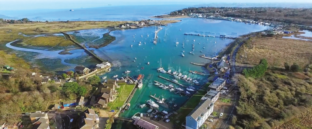
Currently the harbour is privately owned and the owners have recently invested in a dredger which will greatly assist in keeping the harbour open, hopefully ensuring the continued success of Bembridge Harbour as a sailing, fishing and watersports venue.
The Solent Protection Society (SPS) maintains a strong policy regarding the view of coastal land from the sea and this includes maintaining the wooded aspects of the Island shore, minimising development and associated lighting in the coastal woodland areas. The SPS therefore responded strongly to the planning application by Aria Resorts, which has bought the Priory Bay Hotel and who applied for a number of “tree houses” and chalets to be built in the woods immediately above Priory Bay. SPS is pleased to report that the campaign was successful in preventing houses being built in the woodland.
The Bembridge and St Helens area has much of interest to the naturalist. The harbour is a Ramsar Site and the immediate area lies within the Solent European Marine Sites conservation zone. The recently designated Bembridge MCZ (Marine Conservation Zone) covers the offshore coastal area and is considered one of the most biologically diverse marine reserves in the country. The RSPB Brading Marshes Reserve has been under a major management programme for some years to create and maintain the area primarily for waders. The proximity of the relatively peaceful and organically rich mudflats, combined with the careful management of the invertebrates and water levels on the marsh, has provided an important habitat for overwintering and breeding waders. Bitterns were heard booming in the reedbeds last year and are believed to have bred this year, and a recently released white tailed eagle (sea eagle) was photographed on the marsh at
the end of August.
The harbour, marsh and coastal area comprise a mosaic of interesting SSSIs including the St Helens Duver fixed dune and grassland, several saline lagoons and the Whitecliff Bay to Bembridge Ledges SSSI with its interesting limestone tidal rock formations and clay outcrops. This all makes for a wonderful yearround birding, botanical and general natural history experience for all ages and levels of expertise.
The historian is spoilt for choice. The Roman Villa at Brading is very well curated and presented. The huge Bembridge Fort on Culver Down (National Trust) was completed in 1867 to deter attack from the French under Napoleon lll. It was active in both world wars. There are also the remains of the World War ll gun emplacements on Culver Down, all of which speak of more recent history. In previous centuries the fleet would anchor off St Helens to collect local water which was proven to stay fresh for longer than mainland fresh water on extended voyages. Nelson is rumoured to have spent time in St Helens! The Solent offshore forts were also built to protect the Solent from the French fleet. St Helens Fort was built in 1859 to give protection to ships in St Helens Roads anchorage. Fortunately a major attack by Napoleon lll never came.
