
The Met Office got it just about right. But the Solent got off relatively lightly. The main band of winds seems to have headed along the M4 corridor. Even so coastal winds reached almost 100 mph at the Needles.
In mid Channel waves built up to 5 metres high. At Chichester harbour entrance, in the lee of the Isle of Wight, waves of 2.3metres were recorded.Using Solent Now on our website we were able to monitor the progress of the storm
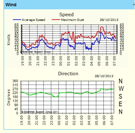
The weather station at the Bramble Bank (below) showed incredible gustiness in the small hours, with average windspeeds of only 10kts, but gusts of 40 Kts.
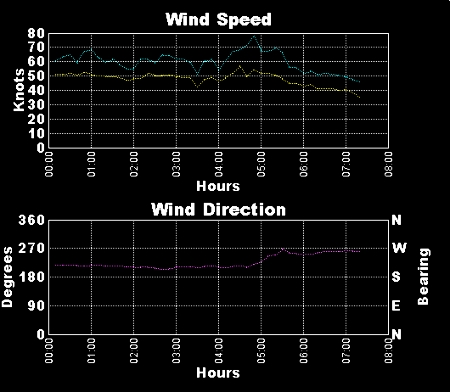
The key point seems to have been at 0500 hrs when The cold front went through. The wind veered from SW to West, and increased to 40 kts gusting to 60kts.
The wind (as expected) funnelled up the West Solent. Weather at Hurst (below) shows that the wind peaked at 80kts.
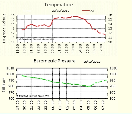
But it was at Southampton that the clearest picture emerged.The barometer dropped at over 4mb per hour, indicating gale force winds or more, until the cold front went through at 0500 hrs. Then pressure kicked up and the temperature fell after the front. This picture is so ‘classic’ that it will probably appear in textbooks in the future!
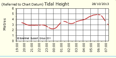
What has received little attention is that the morning tide, predicted to be 3.9m attained 5m, a surge of more than a metre. This resulted from low pressure plus the SW gales piling up the water in the Channel and the west Solent. Had the tides been on Springs, then serious coastal flooding would have happened.
On balance we have got away with it.
