
Our progress report
The English Coastal Path (South) is part of the proposal by Natural England (NE) to achieve as full a coastal path as possible (as required by the Marine and Coastal Access Act 2009) along the area bordering the Solent. It is part of the coastal path project which
covers the whole of England.

In our last newsletter we set out progress on four of the six sections that border the Solent. This left Section 2 – Calshot to Gosport and Section 3 – Isle of Wight to be published for consultation in late 2019 and early 2020.
This report brings the developments up to date. Calshot to Gosport came out for consultation in July 2019 and the Solent Protection Society (SPS), submitted comments by the deadline of 11th September. 2019. Our comments are set out below.
In March 2020 the Isle of Wight section came out for consultation but left out the tricky section between East Cowes and Wootton which is due later this year. The final consultation date for the published section was delayed by Covid but SPS submitted detailed comments in June. These comments are also set out below.
This year we have included the progress map for the whole of England as well as the progress map for the Solent area which puts the Solent progress into context.
Our sections are 15 to 21 on the “All England” map and you will see that some sections have been partially approved. These are in the Calshot to Gosport, Gosport to Portsmouth and South Hayling to East Head sections. However these partial approvals are often very short stretches within the section, so approval by the Secretary of State is fragmented. Having said that, any approval is better than none if it means some of the proposed improvement works, which can be extensive, can get under way.
We believe that the experience Natural England has gained, as the progress of the path consultations has developed over the years, has improved both the information available in the documents and the degree of protection for the many Marine Protected Areas (MPAs) around the Solent coastline. That is not to say everyone will agree, either as a landowner or a conservationist, but generally we feel Natural England has found a fair balance. In some sections we have disagreed with the proposals and suggested alternatives to get a path closer to the coast, in others we have supported them. Our guidance has been to make the Solent shore as accessible as possible without unduly affecting the protected sites of which we are rightly proud.
The task of defining the Coastal Path is a mammoth one and the complexity of our Solent coast has meant a great deal of research and very detailed proposals for which Natural England is to be commended. Of course parts will be controversial but overall we hope it is successful and the new sections and various improvements will come to fruition in the not too distant future.
There remains the East Cowes to Wootton section on the Isle of Wight where there is presently no access to the shore line on a very significant part of the Solent. We hope Natural England and English Heritage and other land owners can find a suitable route through.
Our Comments
Calshot to Gosport:
Generally the Society supports the proposals and is pleased with the links that have been proposed to join up various sections of path and create a more continuous route. It would indeed be nice to find a seaward route past Fawley oil refinery and we would hope NE would keep such an option in mind should circumstances change. Similarly the small detours required on the eastern shore of Southampton Water at Netley and the Holiday Park are a pity. SPS would not favour the alternative routes proposed in various places but would support the proposed line.
SPS accepts that the best of the three options and has been chosen at the three estuary crossings. We support the decision to use the pink ferry at Warsash and the Hythe ferry and note and support the reserve position that Natural England reconsider the matter in the event that either of the ferries cease to operate.
Finally SPS supports the proposed S25A designations proposed throughout the route to exclude the public from the seaward coastal margin in these extensive and important protected areas. We would hope that adequate signage is proposed throughout the route to inform the public of the exclusions and that in critical areas fencing is proposed to physically restrict public and particularly access by dogs.
This will be important if the proposed Fawley Waterside development takes place which will put increased pressure on the path and its margins at the south west corner of the route, but we strongly support the path going on the seaward side of the proposed development.
Isle of Wight Wootton to East Cowes:
IOW-2-S017 and IOW-2-S018. Quarr Abbey Section. There is too long a section of the path between Kite Hill and Ryde where there is no view of the sea. We sympathise with Quarr Abbey as quiet contemplation and prayer is the reason for their being there. Quarr is an important and historical Abbey. However we think there is an important opportunity here to improve the view of the sea. If it is not possible to go along the foreshore, even with a winter exclusion using Quarr Road as the alternative, then perhaps a fenced route through Fishbourne Copse would be possible.
The path could then proceed past the heronry (with adequate conservation safeguards) to return up to Quarr Road to the west of the private properties.
Priory Woods. Map 2g. IOW-2-S089 to end of IOW-2-S092. We would strongly support the proposals through Priory Woods. The path at high level becomes very muddy and sticky in winter so a board walk is needed.
Nodes Point. Map 2g. IOW-2-S093 to end of IOW-2-S097. Strong support again for this section with adequate steps due to the underlying ground.
Ferry Point. Map 2h. IOW-2-S113. Remove this section. We suggest the path should not pass in front of Ferry House to avoid trampling on developing shingle spit with interesting floral assemblage. Suggest short fenced path between the end of IOW-2-S112 and the start of IOW-2-S114. Information board sited at end of IOW-2-S112
Yar Quay Bridge. Map 2h. IOW-2-S125 and S126. We draw your attention to the current Planning Application P/00637/14 for nine houses to be built on IOW-2-S126. Suggest Coastal path to follow the current route to join the B3395 about 150 yards to the West unless a route past the housing can be agreed.
From the “Crab and Lobster carpark” to Bembridge Boarding Campus IOW-2-S150 to S158. This section is frequently closed due to cliff slumping. The option is either to roll back or take Howgate Road (suburban with no view of the sea) so roll back provision is important here.
IOW-7-S025-S112 Hampstead to Porchfield.
Maps 7b ,7c, 7d & 7e. It is clear that NE have tried hard to improve the Coastal Path around the highly sensitive waterside at Newtown and this is welcomed. The section at Western Haven will cut out a long and uninteresting inland section of track on the Hampstead trail and the proposed 7 month exclusion is appropriate for wildlife. As this is a new path we are not familiar with it and more fencing may be required both here and through the nature reserve to ensure there is no access, particularly for dogs, between the path and the water’s edge. Similarly the section through Walters Copse, past Clamerkin and through to Porchfield removes a long section of road walking.
The protections at S095 to S097 seem appropriate and essential but we have no direct knowledge of this section. We are generally pleased with the detailed work on the Isle of Wight path to identify the places for restrictions and signage.
IOW-7-S119-S122 MOD land and Burnt Wood 7f, 7g & Directions Map IOW 7B
We are less happy with this section. While the revision from Porchfeld to Thorness cuts out a section of road which is welcome it does nothing to improve access to the shoreline.
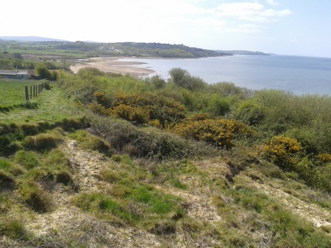
The approximately 1.5 mile section of coast from Newtown to Thorness is the second largest gap in the coastal path fronting the Solent after East Cowes to Fishbourne. The Solent on this stretch has beautiful views across to the New Forest and is an area of water with lots of recreational activity to observe.
We would strongly support the proposal put forward by NE under the option S119 –S125 to align the trail to Brickfields Farm via Shepherds Hill or north of it to return to Burnt Wood, fenced if necessary and following field boundaries. We would ask that this is revisited with the MOD to seek a permissive path which can be closed by the MOD where it leaves the Public Right of Way (PRoW) whenever necessary. A similar arrangement has been made for the ECP at Thorney Island in Chichester Harbour.
We would also support the proposal put forward by NE under the option S120 –S124 to align the trail through Burnt Wood, preferably in conjunction with the MOD land so that it is available when the permissive path is closed. We recognize that there are sensitivities in going through Burnt Wood rather than the cliff edge but would suggest that this option must be included in the proposals for the future. The route could be fenced back from the cliff edge with explanatory signage, a resited badger set could be provided if there was no way round it and the path could return to S123 if there was problem with erosion through to S124.
In the meantime there needs to be a link across the southern end of Burnt Wood from the Public Right of Way (PRoW) to the proposed route at S121 on the east side of Burnt Wood. This would also provide an alternative to the PRoW going through Elmsworth Farm. If the connection through Burnt Wood could be achieved rapidly then there would be no need for the path to the east of the wood.
IOW-8-S001-S014 Thorness to Gurnard Maps 8a & 8b This section of path has fine views of the Solent but does become almost impassable in winter due to the muddy clay conditions. The proposed surfacing works will be a big improvement. The roll back proposals are essential as the cliff is prone to frequent erosion. In at least one section of S011 steps will be required cut into the path.
Just before S014 we would ask that a spur is created and steps provided to the beach in lieu of the path reverting to the old route even though the path would not then go behind Marsh Cottage and would use the present permissive path.
IOW-9-S014 to S021 Spencers Wood. Map 9a
SPS supports the proposal to take the ECP down through Spencers Wood. Replacement steps will be required at S014 and new steps by the slipway to allow safer access to the beach at S022.
IOW-10. Generally Maps 10a to 10f
SPS supports the tidal River Medina being included in the coastal path and are pleased to see that all the land in the coastal margin between the path and the water’s edge at all states of the tide are to be excluded under a S25A direction as set out in 10.2.15.
IOW-10-S070 to S074. Whippingham. Map 10f.
While the reason for following a more inland route from Folly Works is understood, we wonder if a route from just north of the boardwalk and proposed kissing gate could follow the field boundaries to run North to join Saunders Way at S074 and so avoid road walking on Beatrice Avenue and be a more pleasant path and somewhat closer to the water’s edge.
There is no access beyond the bay to Newtown in the distance. SPS have asked that this 1.5 mile section be reviewed to provide a permissive path through part of the MOD land similar to arrangements at Thorney Island.
