There are as many, if not more people using Solent waterways than just the bathers at designated bathing beaches. For a considerable time, SPS has been calling for the scope of Southern Water’s Beachbuoy application to be extended to complete the coverage for the safety and security of all Solent water users, leisure and business, residential and visiting. There are also a number of ‘protected’ areas of scientific interest around the Solent where the natural world is also suffering from the effect of unreported sewage spills.
What we are looking at is not just bathing water quality but water quality across the board. This is a public health issue and whether it relates to bathing, water recreation or food safety is irrelevant. The need to monitor, inform and improve should take priority.
The data already exists
We’ve recently been looking deeper into the wealth of data that the Environment Agency has in its database, content which is brought to life in some of the graphical examples from the EA mapping tool shown in this post.
The Solent is internationally renowned for leisure water activities, from international kite-surfing off the Hayling shore to international yachting throughout Spithead and the Western Solent. With marina developments, sailing clubs and water-sports training facilities right across the Solent region, not to mention local divers, fishermen and sea anglers around the coast and the harbours, the need for openness and clarity over the quality of the water is paramount.
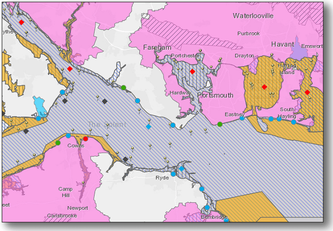
As currently configured, the Southern Water Beachbuoy map display shows a number of coloured icons scattered, mostly around the eastern Solent, each one depicting ‘bathing sites’ with two notable exceptions. These two exceptions represent ‘shellfish water’ reference points in Langstone and Chichester Harbours, where bathing beaches are not to be found but leisure water users and wildlife abound.
Using the Environment Agency’s interactive ‘River basin management’ mapping tool, we can see below that the Beachbuoy ‘Bathing sites’ occupy the same GIS location as the Environment Agency ‘Protected Areas’ for ‘Bathing water’, with the exception of the two additional reference points (shown in red above), in Langstone and Chichester harbours.

By adding the ‘Shellfish waters’ overlay to the mapping, we can see where those two Langstone Harbour and Chichester Harbour Beachbuoy reference points come from, strongly suggesting that the algorithms behind the Beachbuoy web application can already present CSO spill data related to ‘Shellfish water’ protected areas.
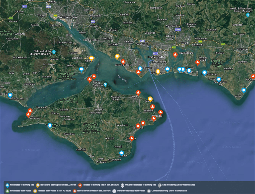
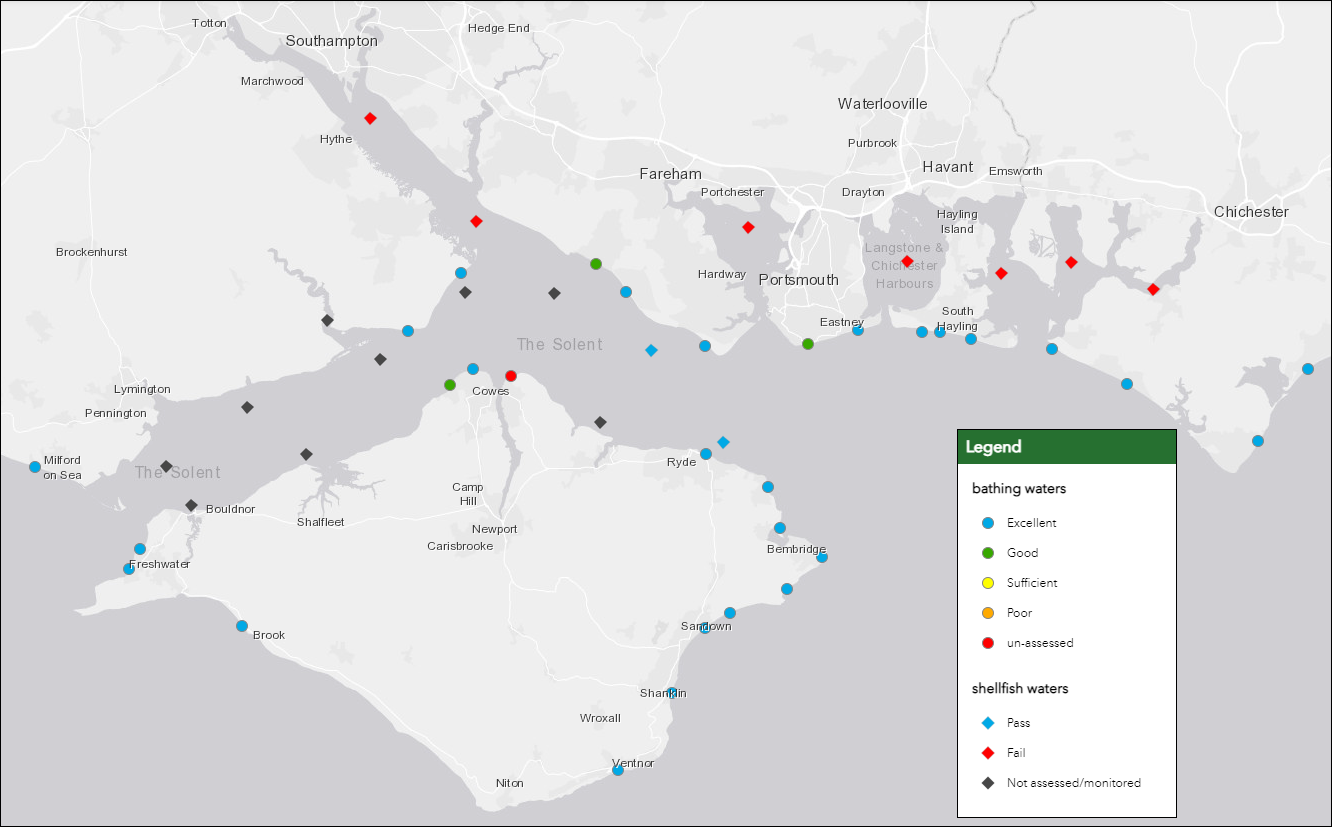
The chart below shows the full set of both ‘Bathing water’ and ‘Shellfish water’ GIS locations mapped across the Solent. Since Southern Water have already enabled two of these in the Beachbuoy application, it should be a simple step to enable the remaining ‘Shellfish water’ locations, thereby switching on comprehensive CSO discharge monitoring for leisure and fishing users at sensitive points across the wider Solent area.
Adding a further data overlay, ‘Shellfish monitoring points’, individual ‘Shellfish monitoring points’ can be superimposed on the map. In the live map, clicking on each of these data points will show further details of the type of shellfish observed and monitored in that location.

To reinforce just how powerful the data is, the following example of the EA data mapping shows the ‘Nitrate vulnerable areas’ and the ‘European Habitat sites’. In the live map, you can click on the areas to follow detail relating to that specific point.


The way forward
Southern Water is neither a nationalised industry nor a philanthropic entity. It is a commercial enterprise, a predominantly foreign-owned monopoly supplier of wastewater treatment services answerable primarily to its financial backers and shareholders. We should not expect it to pander to the environmental whims of its customers. What we can do however is to ensure that our political representatives make absolutely certain that any public money allocated to its projects by Government departments and agencies is wisely spent.
The current OFWAT funding model incentivises the water companies to invest heavily in engineering and technology assets, even when lower cost, environmentally sound alternative options exist. An example of this is the current proposal by Southern Water to build an energy-intensive ‘reverse osmosis’ Water Recycling Plant at Havant, when water transfer in from regions to the west and north is feasible, cost-effective, and environmentally sound. The high-technology solution increases shareholder value, whereas the environmental solution does not.
Solent Protection Society is pleased to be represented on the Southern Water ‘Regional Forum’, chaired by the Rt. Hon. Penny Mordaunt, MP, and look forward to continuing to pursue our request for the open and transparent disclosure of CSO spill data across the complete Solent region.
If you found this article of interest, please consider helping the Solent Protection Society, either through membership or by donation. We would welcome your support.
Please refer to the ‘Membership and Donations’ page.
